
Put the L2 Pro
in the air.
Mount the XGRIDS Lixel L2 Pro to supported DJI Matrice 300 RTK or Matrice 350 RTK aircraft for aerial LiDAR capture, true-colour point clouds and RTK-supported georeferenced workflows.
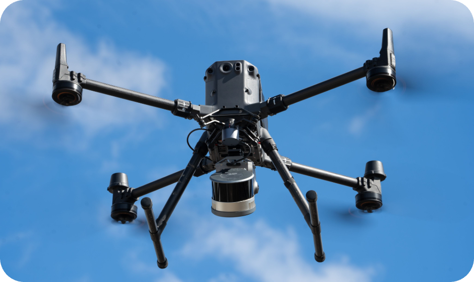
The UAV mount extends the same L2 Pro platform into hard-to-reach and large-area capture. The scanner uses aircraft power, supports RTK workflows and retains colour point-cloud production.
Walk it. Drive it.
Now fly it.
XGRIDS Lixel L2 Pro UAV Mount
Mount the XGRIDS Lixel L2 Pro to supported DJI Matrice 300 RTK or Matrice 350 RTK aircraft for aerial LiDAR capture, true-colour point clouds and RTK-supported georeferenced workflows.
DJI M300 / M350 RTK
Purpose-built mounting workflow for the DJI Matrice 300 RTK and Matrice 350 RTK platforms.
Low-vibration mounting
A stable mounting structure is designed to maintain reliable scanner positioning during aerial capture.
RTK-compatible capture
Use the aircraft/L2 Pro RTK workflow to support georeferenced aerial datasets.
True-colour point clouds
Combine LiDAR geometry with L2 Pro panoramic imagery for coloured aerial point-cloud deliverables.
Built around
field deployment.
These values describe the mounting/deployment system. Scanner accuracy and final deliverable quality still depend on the L2 Pro configuration, control, trajectory, environment and processing workflow.
Specifications and supported workflows can change with hardware/firmware revisions. True Point Precision will confirm current compatibility when quoting the system.
A complete mounting system is more than the bracket itself. The supplied cables, power components, adapters and hardware are what make the deployment field-ready.
What comes
with the mount.
XGRIDS Lixel L2 Pro UAV Mount
- ✓UAV mounting bracket
- ✓Gimbal adapter ring
- ✓Power cable
- ✓USB-C / Type-C cable
- ✓Tool kit
- ✓User manual
Deploy the L2 Pro
around the site.
The value of the mount is simple: keep the same scanner platform while changing how the site is covered.
Topographic & terrain capture
Collect large outdoor areas from above when walking the entire site is inefficient.
Construction progress
Capture roofs, site context, earthworks and large construction zones from a consistent aerial perspective.
Agriculture & forestry
Document terrain, canopy and broad outdoor environments with aerial LiDAR coverage.
Hard-to-reach infrastructure
Extend reality capture to areas where handheld access is difficult or unsafe.
Mounting an L2 Pro changes the deployment workflow, so compatibility, safety, control and project planning matter more than a simple accessory SKU.
Before you
deploy it.
Which drones are supported?
Does it support DJI Matrice 400?
What flight altitude is recommended?
How fast should the drone fly?
Does the L2 Pro use the aircraft power?
Can True Point Precision help configure the complete aerial workflow?
Need the complete L2 Pro deployment kit?
Tell us the scanner configuration, project type, control requirements and deployment method. True Point Precision can configure the L2 Pro, mount, RTK and field workflow together.