
Scan farther.
Map faster.
Keep moving.
Real-time SLAM, RTK, dual 48MP vision, and up to 300 m LiDAR range — handheld, vehicle-mounted, or drone-deployed.
Lixel L2 Pro combines rotating LiDAR, panoramic vision, high-precision IMU, and multi-SLAM to create colourized point clouds in real time. Start handheld, add the vehicle mount for rapid mobile mapping, or deploy it from a supported DJI drone for aerial capture.

Real-time data.
Less waiting.
L2 Pro is designed to make mobile scanning feel more like a production tool and less like a collection device that creates hours of downstream cleanup.
Capture the site while the system builds the map.
The scanner combines LiDAR, vision, IMU, and positioning so you can review the developing point cloud and field status during capture instead of discovering problems back at the office.
Colourized point clouds in the field
Dual panoramic cameras and real-time reconstruction provide visual feedback during collection.
RTK-supported positioning
Real-time RTK fusion supports georeferenced point clouds and continuity through short GNSS interruptions.
Capture. Process.
Deliver.
L2 Pro supports a direct field-to-office workflow through LixelGO and LixelStudio for point-cloud capture, control, reconstruction, optimization, and export.
Walk the environment
Use real-time mapping, visual feedback, RTK/PPK workflows, and field status information to capture confidently.
Optimize in LixelStudio
Process collected data into clean, dense point clouds and supporting imagery for downstream production.
Move into your project tools
Export point-cloud and image deliverables into CAD, BIM, survey, engineering, and visualization workflows.
Lixel L2 Pro
specifications.
Core platform specifications. LiDAR channel count and maximum range vary by configuration.
Accuracy & Positioning
Hardware
Capture & Output
Want to see L2 Pro on your type of site?
We can walk through range, accuracy, RTK, outputs, and the right configuration before you buy.
Same platform.
Different reach.
L2 Pro is available in three configurations. The right choice depends on range, point density, site scale, and budget.
Balanced field capture
Points per second with up to 120 m scan range. A strong fit for general AEC, building, and facility capture.
More density at the same reach
Points per second with up to 120 m range for denser capture across complex environments.
Long-range mobile LiDAR
Maximum range configuration for larger sites, infrastructure, exterior work, and long-distance collection.
Walk it. Drive it.
Fly it.
L2 Pro is more than a handheld SLAM scanner. XGRIDS accessories let the same platform move from pedestrian capture to vehicle-mounted mobile mapping and drone-based aerial LiDAR.
Walk the site
Use the standard L2 Pro configuration for buildings, plants, construction, infrastructure, and other environments where a mobile operator can move directly through the scene.

Turn L2 Pro into mobile mapping
The dedicated vehicle mounting system is built for rapid large-area scanning from a moving vehicle, with recommended usage around 20–30 km/h and maximum speed up to 40 km/h.
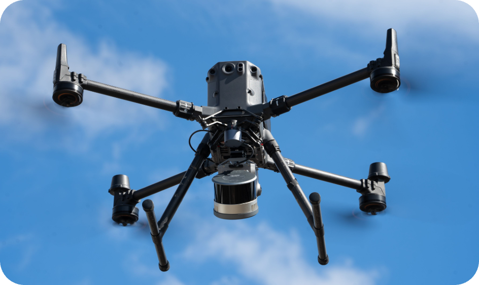
Take L2 Pro into the air
The L2 Pro drone mounting bracket supports DJI Matrice 300 RTK and Matrice 350 RTK platforms, combining airborne mobility with LiDAR capture for large or difficult-to-reach sites.
Contact us for the latest supported UAV platforms and mounting options.
Explore drone mount →Handheld, vehicle, or drone?
Tell us how you plan to capture and we’ll help configure the L2 Pro workflow around the project.
Make the data
visible.
Replace these placeholders with one field capture video, one real point-cloud example, and one downstream BIM or engineering deliverable.
From plant floors
to infrastructure.
L2 Pro is best suited to projects where range, mobility, field productivity, and engineering-oriented point-cloud deliverables matter.
Plants & Manufacturing
Capture production areas, equipment, MEP systems, access routes, and existing conditions with a mobile workflow.
Construction & Architecture
Document existing conditions, progress, renovation scope, façades, interiors, and complex geometry.
Roads, Tunnels & Large Sites
Use multi-SLAM, positioning, and long-range LiDAR for larger linear or degraded-GNSS environments.
Survey & Mapping
Combine mobile capture with control, RTK, PPK, and georeferenced point-cloud workflows.
See what L2 Pro can cover in one walk.
Tell us the site size, environment, range requirement, and deliverable. We'll help you choose the right L2 Pro configuration — or tell you if K2 is the better fit.
Lightweight precision or maximum field reach?
K2 is the newer lightweight platform for compact engineering capture. L2 Pro remains the stronger fit when longer range, higher point rates, larger sites, RTK/PPK workflows, and multiple LiDAR configurations are the priority.
Lightweight engineering capture
Compact 1.2 kg platform focused on 1 cm-class relative accuracy and fast everyday capture.
Range, density & positioning
Up to 300 m LiDAR, 32-channel options, RTK/PPK workflows, and larger-scale mobile mapping.
L2 Pro
FAQ.
Common questions about range, accuracy, configurations, RTK, and where L2 Pro fits in the XGRIDS hardware lineup.